

Low Spots, High Stakes: DEMs and the Hidden Cost of Elevation Blindness
Discover how Digital Elevation Models (DEMs) Reveal Drainage Issues, Tree Stress, and Yield-Limiting Terrain in Orchard farming.

Every orchard has a hidden layer of risk written into its landscape. You may not see it from the ground, but elevation dictates how water drains, where soil moves, and which trees will struggle.
Failing to account for these patterns is a form of “elevation blindness” - a gap in vision that can quietly erode yields and profitability.
Digital Elevation Models (DEMs) remove that blindness, pulling terrain influences into focus and turning invisible risks into maps farmers can act on.
DEM, DSM & DTM: Speaking the Same Language
You'll often see acronyms like DSM (Digital Surface Model) and DTM (Digital Terrain Model). Here’s how they differ:
DEM is the umbrella term for surface-elevation data.
DSM includes every object on or above the ground—trees, buildings, canopy.
DTM represents bare earth only, stripped of vegetation and structures for pure terrain analysis.
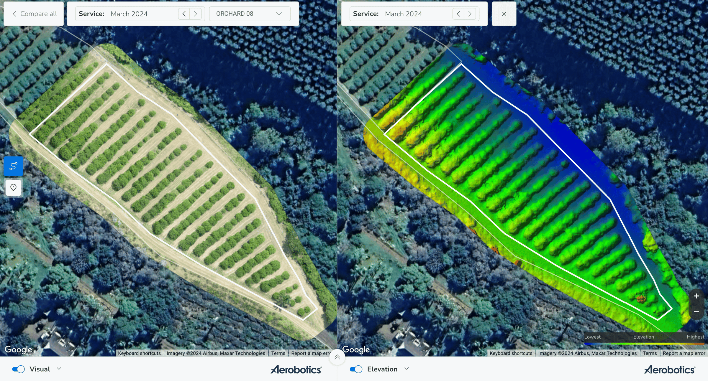
In most drone-based orchard use cases, DTM (or a DEM in DTM form) is ideal for drainage and slope analysis; and especially where canopy features would be seen as “noise”.
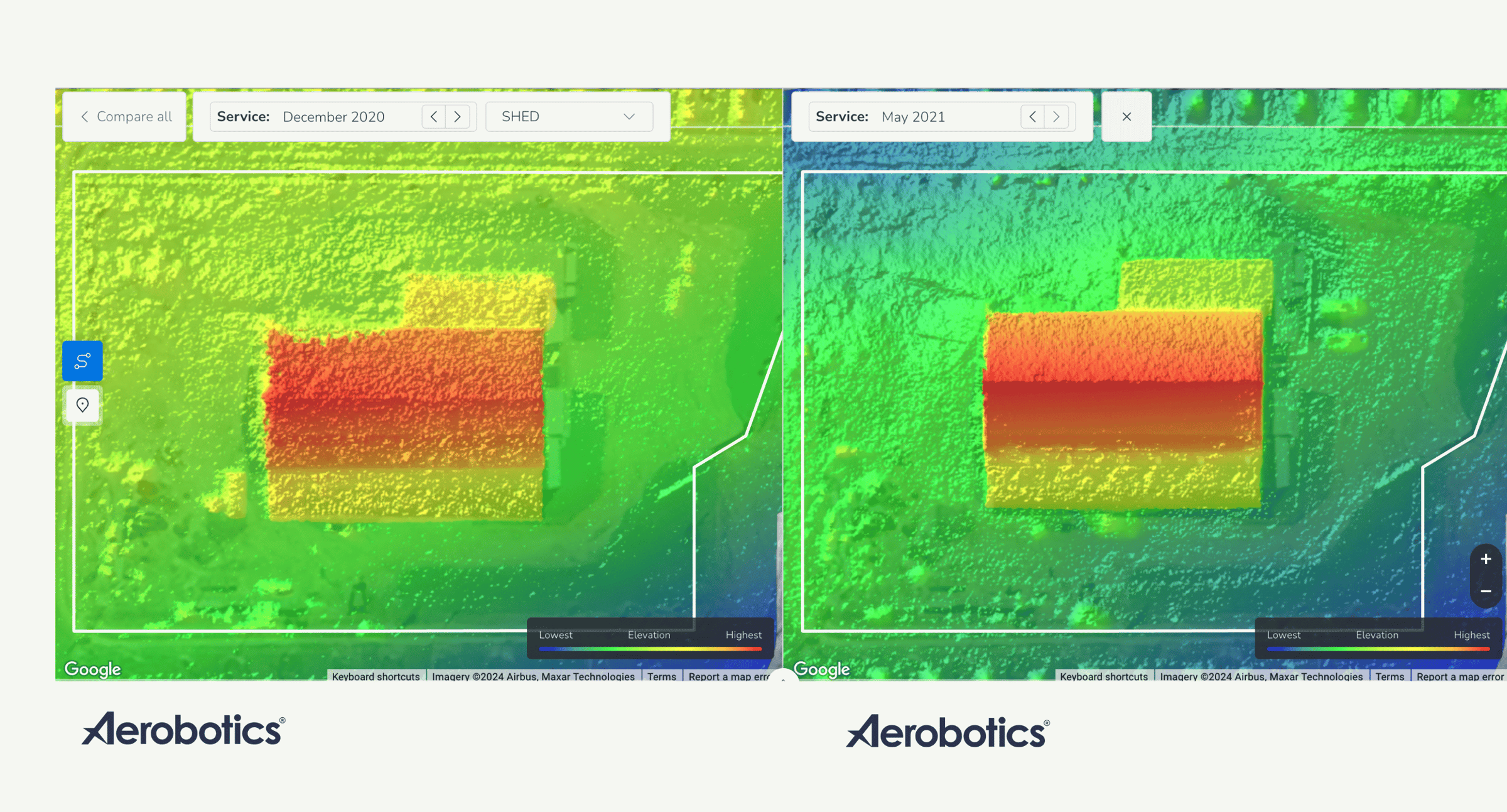
In the image above, a DEM was generated over the same area in 2020 vs 2021. DEM resolution and quality has steadily been improving to offer us with greater clarity and insights into terrain characteristics. These advancements are continual, and nowadays DEM data provides greater clarity and precision than ever before.
How DEMs Are Created
DEMs are typically generated using structure-from-motion (SfM) photogrammetry algorithms applied to overlapping drone imagery.
Modern tools like Pix4D, Agisoft Metashape, or the Aerobotics platform (the easiest to use in my opinion) process these images and triangulate elevation points across the scene; producing useful maps.
LIDAR-based models can also be used to derive DTMs; especially useful in heavily forested areas to penetrate canopy. Companies like Drone Solutions International regularly conduct these types of surveys.
Formats such as GeoTIFF (.tiff) are common, with spatial resolution ranging from 5–30 cm for drone surveys to 5–30 m for satellite-derived datasets. Platforms like Hammer Missions use DEMs in GeoTIFF format to generate terrain‑following flight paths, ensuring consistent data quality even on slopes.
DEM Use Cases in Orchard Management
Here’s where DEMs really shine in perennial crop operations:
Water Management & Irrigation Planning
DEMs let you model natural flow paths and water pooling zones. Orchard plannign that takes this into account helps to prevent waterlogging and optimise gravity-fed distribution schemes.
Erosion Risk Mitigation
Identify slopes and gullies before they become destructive. Plan terracing, buffer strips, or contour planting to preserve soil health.
Infrastructure planning is often overlooked - how will (or does) traffic disturb the land and impact orchard performance due to changes in terrain or terrain characteristics?
Variable Rate Application (VRA) Maps
Incorporating terrain into VRA ensures that fertiliser or pesticide spreads evenly, despite flow-related variations across the block.
Planting & Infrastructure Planning
Want to build roads, pivots, sheds, or plant higher-value cultivars? DEM-based slope maps inform where it's safest and most productive to build or plant.
Stress Diagnosis & Crop Health Correlation
Layering DEM with NDVI/NDRE can reveal segments of an orchard where high moisture or poor drainage suppress canopy vigour. These areas often correlate with low elevation zones.

Real-World Macadamia Orchard Example
In a South African orchard, drone surveys in 2022-2024 revealed a recurring cluster of underperforming trees. The RGB and NDRE data flagged these stress patterns, but it was the elevation layer that offered context. Trees were located in a depression. Low-lying ground where water drained to and pooled; and soil structure degraded over time.
Here’s how interventions worked:
Initial drone data confirmed low performance trees, identifying the epicentre, and quantifying the scale of the issue.
An elevation layer analysis identified the low zone.
Targeted soil sampling confirmed compaction and silt buildup.
In-field remediation included rip lines, drainage pathways, and canopy adjustments.
Follow-up DEM and canopy surveys over time showed reduced variance, tighter canopy distribution, and improved yield.
This process turned terrain insight into measurable ROI; capturing growth trends that would not have been evident through visual data alone.
Targeted Ground Scouting & Diagnostics
With DEM-based insights, sampling becomes surgical. Farm teams can:
Drop inspection pins on terrain anomalies.
Monitor zones of concern over time.
Collaborate via online platforms where field notes and aerial data align seamlessly.
This reduces wasted field time and leads to informed, efficient interventions.
5. Tracking Change & Validating Interventions
The real advantage of DEMs shows up over time.
With repeated annual surveys, you can quantify:
Changes in soil levels or drainage.
Tree recovery in remediated zones.
Shifts in canopy size distributions and stress signatures.
Changes in terrain after severe weather events.
These metrics support evidence-based reviews "did this intervention make a difference?" instead of relying on anecdote.
Key Takeaways
DEMs are more than maps; they’re decision tools.
Use DTM-quality elevation data to remove noise from canopy features and focus on the true terrain.
Pair DEM with multispectral and canopy layers to uncover root causes of stress.
Enable targeted sampling and informed interventions.
Track year‑on‑year terrain and canopy changes to measure ROI.
As someone working at the intersection of GIS, agronomy, and drone technology for clients engaged in perennial crop systems, I can attest: minimal cost delivers maximal value with DEMs. Especially when converted into DTM-quality raster layers and integrated into platforms like Aerobotics or QGIS.
If you’re already running RGB or multispectral drone data workflows, consider elevating your insights, quite literally! Your elevation model layer may hold the answers you’ve been missing in your orchard analysis.
Call to Action:
Download the full Drone Data Metrics eBook by joining the mini email course to master DEMs, RGB, NDVI/NDRE, thermal data, and actionable analytics for orchard and vineyard decision-makers.
Drone Data Metrics (Free email course)

If you want to learn more about the core sets of drone data you can utilise for enhancing agricultural efficiencies, this free course is for you!
Terrain Truths: Using DEMs to Unlock Orchard Potential - Your FAQs Answered

After my recent post on using Digital Elevation Models (DEMs) to improve orchard planning and management, a number of readers reached out with excellent follow‑up questions.
Unlocking the Power of Drone Data - Introducing the Drone Data Metrics eBook

Agriculture is shifting fast. Precision tools that once felt out of reach are now part of everyday orchard management. Drones are at the centre of this change.


